


Friday, February 24 2023
Whether it’s mining for gold, silver, lead, zinc or other precious metals, it’s always fun to follow in the historic footsteps of the old time Electricity changed the world from a predominantly rural society to the industrial age, and copper wire was needed to carry that electricity— and lots of it. Thanks to the insatiable demand for electricity, Bisbee was one of the greatest copper camps in the world. In nearly 100 years of continuous production (late 1880s until the mine closed in 1975), the local mines produced metals valued at $6.1 billion (at 1975 prices). This staggering amount of wealth came from the estimated production of 8,032,352,000 pounds of copper, 2,871,786 ounces of gold, 77,162,986 ounces of silver, 304,627,600 pounds of lead and 371,945,900 pounds of zinc. The story of Bisbee mining began in the late 1870s when Lt. Dunn, in charge of a cavalry detail from the frontier Army post of Fort Copper production began on a limited basis around 1880. At the time, those who toiled in subterranean tunnels beneath the Mule Mountains were mostly immigrant miners from Europe. Individuals and then companies with capital gradually became involved and took over individual claims and brought them into production. Phelps Dodge Corporation, through a subsidiary the Copper Queen Consolidated Mining Company, became the dominant force and eventually the sole operator of the mining district. Building on its base in Bisbee, Phelps Dodge had long been one of the largest copper producers in the United States. Although mining was closed in 1975, the Queen Mine Tour was officially opened in 1976 to keep the story of mining alive in Bisbee. Since then, millions of visitors from around the world have enjoyed the trip into the mountain on the underground mine tour train.
Tuesday, February 11 2020
The big gold rushes of the 19th century have long since ended, but in most cases you can still prospect for the precious metal in these Below is a very short list that offers a few ideas only. Beginners should search the internet or join a local gold prospecting organization for more information.
Keep in mind that even if there has been no major “rush,” major amounts of gold have been found in many other states, too, including Georgia, Michigan, Montana, New Mexico, Oregon, South Carolina, Tennessee, Texas, Utah, Virginia, Washington, Wisconsin, and Wyoming. Good luck! Sunday, December 30 2018
When prospecting an area that’s known for gold, put yourself in the boots of the old-timers who came before to Host rock (or bedrock) could be shale, diorite, granite, quartz, clay or other material. Keep an eye out for changes in the area’s host rock and notice the direction in which it’s running. Contact zones occur when a rock or mineral cuts or crosses the host rock. Generally, gold is deposited along contact zones, which can be a few inches or several hundred feet wide. If bedrock in your area runs north to south and you notice a color change in material that runs east to west, you’ve found a contact zone. Outcroppings are a lump of high ground with weather-worn rocks which are generally rounded and usually situated on ridges, but can be located anywhere. Especially look for iron staining on outcroppings. Ditch lines of yesteryear were generally dug into and run along somewhat level ground. Very close to diggings, especially in hilly or steep terrain, they may have been cut loose to wash downhill. Follow the old water ditches and see where they end up. Exploratory trenches were not used for water but most of the time were deeper and would often circumnavigate a rich area that may be throwing gold from clay lines, pockets, quartz seams and any other local contacts. Trenches were dug simply to expose any contacts that may be present. As a contact was crossed, old-timers checked it out in both directions for values. Rock cairns are piles of rock or stone used for claim corners. Standing high on a slope looking down is a great vantage point from which to spot cairns and other man-made landmarks. By locating a historic claim, you definitely have a great place to begin! Tuesday, February 06 2018
Historically, California has been known as the land of the big nuggets. After the Gold Rush began in 1849, Plenty of stories abound from California, but plenty of big gold has come from other states as well. Colorado's biggest nugget weighed in at 156 ounces (13 troy pounds). It came from the Gold Flake mine located on Farmcomb Hill in Summit County, Colorado in 1877. It's easy to see why Montana's nickname is the "Treasure State" since it has produced a few big nuggets, too. One weighed 53 ounces and was displayed at the Paris World Expoition of 1889. The largest in Montana was over 170 ounces and was dug at a depth of 12 feet in Snow Shoe Gulch on the Little Blackfoot River. Nevada's largest nugget was taken from the diggings of the Osceola District in 1878. It weighed 24 pounds (but eight pounds of that was quartz). The old Spanish miners found plenty of big gold in New Mexico, including one nugget in the late 1890s that weighed over 65 ounces.
North Carolina's claim to fame is the Reed Gold Mine located in Cabarrus County. It was the site of the first documented discovery of gold in 1799. For years, that 17 pound nugget was used as a doorstop because no one recognized what it was! At the time, it was worth roughly $4,000 (when the price of gold was $20.67 for an ounce). The Reed Mine actually produced a lot of big gold, including some weighing 28 pounds, 17 pounds, 16 pounds, and 13 pounds. Two different nuggets came from this area that weighed eight pounds each and another two nuggets were nine pounds each. Several more nuggets have been unearthed that weighed five pounds and less. These examples of where large nuggets have been found are by no means exhaustive. A Google search will provide lots of fun stories about past and present finds across the United States. But no matter who has found what, the big question remains: Where do you hunt for big gold these days? Generally, big nuggets occur in places where rich gold-bearing fluids flow through the same pathways for a long period of time, allowing continued deposition of gol The simple answer to where to hunt for big nuggets is to hunt where they have been found in the past. Past finds of big gold indicates these locations have the right geology for their formation. Big nuggets in a stream environment will work their way to bedrock very fast and stay put. They will often be lodged in deep crevices. Keep in mind that big nuggets are also worth more than their actual metal value. The fact they are so rare adds to their value. If you haven't found your big gold yet, keep looking! And if you can't wait to own your own shiny stuff, buy gold nuggets here. Nugget of News Blog Saturday, May 09 2015
In July 1986, Life magazine described Nevada’s U.S. Highway 50 between Ely and Fernley as the “Loneliest Lead and silver ore was first discovered in Eureka during the fall of 1864 when a party of five prospectors traveling 70 mile from the silver camp of Austin to explore the area. Unlike most new mining strikes, not much excitement was caused by this find— not because the assays of the rock weren’t favorable, because they were, but because the smelting methods available at the time were not suited to treat the oxidized gold-silver-lead ores (those which are found above the water level) they had found. The ore was rich in iron and arsenic and occurred in a form that was hard for the miners to process economically. When smelters were perfected and constructed several years later, mining boomed. The 16 smelters around town certainly didn’t improve air quality, but perhaps it was the 100 saloons that helped the nearly 10,000 residents forget about the pollution! At about that same time, several rich ore bodies on Ruby Hill were discovered, and as a result, the Eureka mining district became quite prosperous. Because of the town's central location in the state, it became a railhead for the whole area, which kept Eureka alive even after production decreased. Most of the district’s production was made between 1870 and 1890. Although there have been large amounts of gold produced in the last 50 years, the recorded production up to 1964 was approximately 313,000 tons of lead, 7,000 tons of zinc, 1,000 tons of copper, 1.65 million ounces of gold, and 39 million ounces of silver. These production totals are probably understated since records prior to 1901 were incomplete. Since 1964, nearly 1.5 million ounc To get a sense of Eureka’s past, and see dozens of historic buildings and sites in downtown, pick up a self-guided walking tour map at the Sentinel Museum, then spend a couple of hours or all day stepping back in time. A few highlights include: Eureka Opera House, built 1879, has been fully restored and now serves as a convention center and auditorium. Elegant features such as a chandelier, curtain, wood floors and horseshoe balcony (one of only three horseshoe-shaped balconies in Nevada) have been preserved. Historic graffiti has been preserved back stage from the early days, and the tradition has been continued with signatures of the people who have performed at the Eureka Opera House since it was reopened.
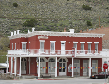
The 1877 Jackson House next door to the Opera House has been beautifully restored and has nine Victorian bedrooms upstairs, and a bar and restaurant downstairs. The brick Eureka Sentinel Newspaper Building dates from 1879 and now houses a museum. This structure was used as the newspaper office and residence until 1960, and was made into a county historical museum in 1982. The downstairs press room, shown above, features all original equipment on which the Sentinel was printed in the boom days of Eureka. Old copies of the Sentinel are tacked on the walls. In the mining history room upstairs you will see tools from the early days of mining, as well as historic stock certificates, ledgers and personal miners items. Lifestyle artifacts from the early days of Eureka are there, too, including items from schools, homes, and businesses. IF YOU GO: 10 North Monroe Street (right behind the Courthouse) Eureka, Nevada Phone: 775-237-5010 November – April: Tuesday through Saturday 10 a.m. to 6 p.m. May – October: 7 days per week 10 a.m. to 6 p.m.
31 South Main Street, Eureka, NV 89316 Phone: 775-237-6006 Monday, September 01 2014
In the spring of 1859, flakes of gold were found in Clear Creek, a tributary of the South Platte River in north central Colorado. Some prospectors were happy finding rich gold dust, but John Gregory w Within two months of Gregory’s initial gold discovery, 900 fortune-seekers were living in log shanties and tents. By the following summer, the population had swollen to 10,000. In no time, businesses and mills were thriving and the area became the leading mining center in the Kansas Territory. At this time, Colorado wasn’t yet a state, but its prominent place in mining history was already secured. Between 1859 and 1918 (considered by the National Register of Historical Places to be the area’s “period of significance”), the total gold output was $83,364,157! Most of this was in the form of placer gold, which was extracted with pans and sluices. This “easy” gold played out within the first five years of discovery, and by the end of 1863, most work had shifted to hard rock mining. The promise of riches continues to lure people to Central City today, but it’s not so much to find gold— but to gamble. Limited stakes gaming was legalized in 1991, and has made this area an important destination once again. Gambling was big business here in the 1880s, drawing the likes of Doc Holliday, and even Soapy Smith all the way from Alaska. The downtown core is now a National Historic District, and casinos reside in many of the restored historic buildings. Much of the beautiful and original woodwork, ceilings, and ornate furnishings date back to the 1870s. A scenic loop drive in the hills above the town is the place to find gold rush cemeteries, abandoned mines, headframes, and many other mining relics. Take a Walk The best way to learn more about Central City’s gold rush and admire its architecture at the same time is to stop at the Visitor Center on Eureka Street for a walking tour map. Choose from several self-guided walking tours, depending on your interests. Many of the town’s most magnificent buildings are in downtown, whereas Victorian residences are located outside of the business district. No matter how much ground you want to cover on foot, keep in mind you’re above 8,000 feet in elevation here, so pace yourself. Some buildings are open for guided tours (admission charged) but even if you don’t peek inside, you’ll get a good sense of the town’s history right from the street. If you want to shake hands with one-armed bandits or play poker at any time during your walk, you’ll find a chance to meet Lady Luck every step of the way.
In April of 1873, President Ulysses S. Grant came to see his friend Henry Teller. To impress the president, mine owners decided to lay 26 ingots of solid silver to make a path to the entrance to the Teller House so President Grant wouldn’t have to dirty his boots when he stepped from his carriage. Those wealthy citizens also had an ulterior political motive. At the time, Congress was debating whether gold or silver should back the dollar. Legend has it that Grant became angry when he saw the silver bars and walked up the boardwalk instead of on the silver path so as not to show favoritism. As we know, gold eventually won. The grand opening of the Opera House in 1878 (next door to the Teller House Hotel) started a tradition of community theatre, ranging from opera to vaudeville. Buffalo Bill Cody performed here as well as P. T. Barnum’s circus. The Opera House is known for its elaborately frescoed ceiling and perfect acoustics. In addition to Central City’s very popular Opera Festival held each summer, performances are held year round in this beautifully restored 550-seat theatre. The Opera Association also owns the Williams Stables building on Eureka Street. Initially constructed in 1876 for the use of Teller House guests, the building was purchased a few years later by Sheriff Dick Williams and his son. It was from here that a Stanley Steamer automobile could be had for hire— quite an achievement back in the day! Many of the Main Street establishments are identified by “blocks” and named for their original builders. In addition to the Teller House Hotel, Henry Teller also built the Teller Block for $6,000 in 1874. The upper floor was purchased a few years later by the Independent Order of Odd Fellows, which retained ownership until the 1990s. The Mullen Block was completed in 1874 by Thomas Mullen. Originally a drug store and clothing store, the Elks Lodge bought the building in 1902. The Harris Block was built in 1875 by Robert Harris and was home to the New York Store Mercantile that sold dry goods, clothing, and furnishings. Gold in Them Thar Hills The scenic forested hills above town offer evidence of the thousands of mining claims that placed Central City and the surrounding area in the history books. When you’re ready to take a short loop drive, the helpful staff at the Visitor Center will point you in the right direction. The route is mostly a well-maintained dirt road that takes you past headframes, abandoned mines, and sites of once thriving communities. Nevadaville is one such mining camp that 1,200 gold seekers used to call home. Along the route you’ll see the Coeur d’Alene Mine. Originally opened by Robert Cameron in 1894, the shaft reaches some 700 feet into the depths of Gunnell Hill. Records indicated that in 1915 this mine employed nine men who earned from $3-$4 per day. You’ll also see the shaft house of the Boodle Mill. Because of the serious safety hazard posed by abandoned mines, trespassing laws are strictly enforced. Although tempting to explore, keep away from old mines and tailings to avoid accidents.
The loop drive also takes you through the “cemetery district.” Many stories are told through the memorials and headstones. Harsh weather, less-than-clean water, mining accidents, and few physicians were the norm during the gold rush. So were epidemics of scarlet fever, diphtheria, and the Spanish flu. Sadly, you’ll notice that a large number of children are interred within the cemetery fences. When you visit, please remember these sites are historical grounds, but are also still in use today. The Gilpin County Historical Society also holds an annual “Cemetery Crawl.” "Oh My Gawd Road" After getting your fill of gold rush history and gambling, a popular route leading out of Central City to Idaho Springs takes about 30 minutes. It isn’t quite as bad as its moniker, but it’s not for the faint of heart either. The “Oh My Gawd” Road (CR 279) is more dirt than pavement and wouldn’t be wise for drivers who don’t like narrow, twisty roads, but the mountain views make it worth it. Along the bumpy route you’ll pass the famous “Glory Hole” mine workings, drive through Russell Gulch, and see many more mining relics that attest to “The Richest Square Mile on Earth” in days gone by. IF YOU GO: Central City is located in the Rocky Mountains, only 35 miles west of Denver. With the newly opened, Central City Parkway, visitors can reach Central City 12 minutes after exiting off of I-70 at exit 243. The Central City Visitors Center is located at 103 Eureka Street, at the northern end of Main Street in the old Wells Fargo Building. Articles and photos by Denise Seith. This article first appeared in the May 2014 issue of Gold Prospectors Magazine, published by the Gold Prospectors Association of America (GPAA). Saturday, March 01 2014
Natural Factors to Consider Before Digging for Gold:
Monday, January 07 2013
Following the discovery of gold in Coloma, California on January 24, 1848, boomtowns sprang up quicker than weeds. Just eight miles away, Old Dry Diggins was one such tent-filled mining camp that took root. So named because miners had to move cartloads of dry soil to running water in order to separate out the gold, the population quickly swelled from hundreds of gold seekers to thousands. As to be expected, things got a little lawless and wild, and the name changed to Hangtown after numerous hangings took place in quick succession. Today, we know this historic gold rush town as Placerville, California.
 Most early prospectors got the gold by panning and sluicing. Gold was easier to see and easier to recover that way. Eventually, though, the “easy money” ran out and more and more small mining companies and individuals turned to hard rock mining. Take a self-guided walking tour of the Gold Bug Mine in Placerville’s Gold Bug Park, and you’ll see how these miners dug drifts (horizontal tunnels) into hillsides to follow the veins of quartz and gold. 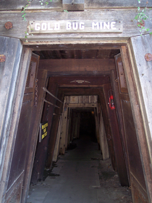 The Gold Bug Mine (originally the Hattie Mine) is a typical hard rock mine found in the Mother Lode. If you haven’t had the opportunity to safely explore an underground mine, or want to introduce your kids to a little fun and history, Gold Bug Park is ideal. Not only can you can go underground, but you can visit a stamp mill and blacksmith shop, have a picnic, and do a little hiking, too. When you buy your tour ticket, you’ll get a hard hat to wear and a hand-held audio wand. As you make your way through the mine, the voice of an old-timer tells the tales of the Gold Bug and the California Gold Rush. Article continued here... Tuesday, May 15 2012
Following the discovery of gold in Coloma, California on January 24, 1848, boomtowns sprang up quicker than weeds. Just eight miles away, Old Dry Diggins was one such tent-filled mining camp that took root. So named because miners had to move cartloads of dry soil to running water in order to separate out the gold, the population quickly swelled from hundreds of gold seekers to thousands.
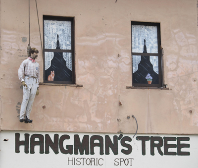 As to be expected, things got a little lawless and wild, and the name changed to Hangtown after numerous hangings took place in quick succession. Today, we know this historic gold rush town as Placerville, which has been the El Dorado county seat for the last 155 years. 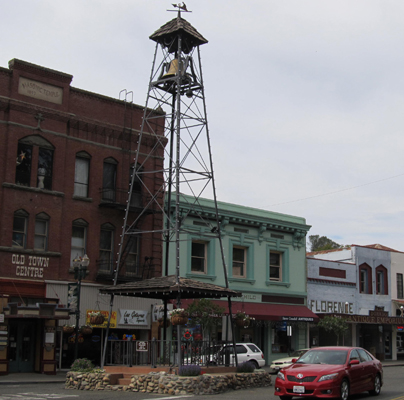 Over the years, Placerville has lost many of its old buildings due to fire and demolition, but some landmarks, such as its bell tower, still exist. It was once used as a warning bell for fire and is located in downtown Placerville . |
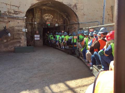 miners. To do exactly that and learn how copper and other ore was first mined in Bisbee, Arizona, take the underground Queen Mine tour. Outfitted with hard hat, miner’s headlamp and a neon vest, visitors ride 1,500 feet into the mine and learn about equipment, techniques, dangers and a century worth of history. Tour guides are actual retired miners, so you know you’ll get the real highlights of working underground. You’ll learn about blasting with dynamite, the role of mules, and even how miners went to the bathroom while working in the mines!
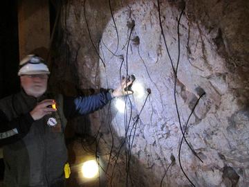 Huachuca, was on a scouting mission against the Apache Indians. Lt. Dunn and his men camped on a spot that is now occupied by Old Bisbee, only several hundred yards from the beginning of today’s mine tour. On a walk after dinner, Lt. Dunn picked up an interesting rock. He found a few more pieces along the slope of the south wall of the canyon. Unable to do anything about it because of military duties, Dunn took a prospector by the name of George Warren into his confidence and struck up a deal by which Warren would locate claims and work the property with Dunn as a partner. But on his way to the site, prospector Warren stopped to enjoy his favorite pastime—drinking whiskey with friends. Warren soon had new partners and staked a group of claims with them, leaving Dunn completely out of the deal.
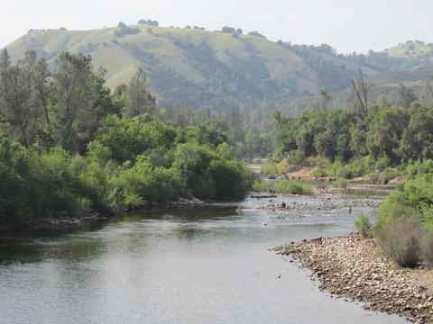 same historic areas. If you’re interested in giving recreational gold mining a try but not sure where to go, below are some key locations where you can still find the yellow metal by gold panning or metal detecting. Since gold was found in these areas, likely the old-timers didn’t get it all— so you may get lucky and strike it rich (or at least catch gold fever)! Rules and regulations differ from state to state, so always be aware of the local laws. And if you want to
  Clear Creek, Colorado. A gold-hunter's paradise, this river in Colorado is hands-down the best place in the state for recreational prospecting. Panning and sluicing for gold is permitted on the river bed at Arapahoe Bar in west Denver, and digging is allowed on the north side of the river there. There's also a large stretch of river about 10 miles upstream from Arapahoe Bar at Clear Creek Canyon where gold panning and sluicing are permitted. You may even have better luck here since the location is up-river.
 help you decide where to begin. Look at your site from all directions and think about what they could and could not do way back then. Your modern-day equipment and knowledge are a lot more advanced than what they had to work with, so you’re already a step ahead! Many times miners jumped in with both feet and started mining to beat the other guys. But being in a hurry meant they could have missed a lot, or moved on too quickly from their original discovery before it was completely worked out. Considering the lay of the land will reveal important clues that can help you better formulate a plan when you're out in the field. Here’s what to look for:
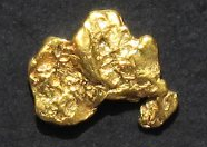
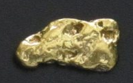 Unlike many Western states, the largest nugget in Alaska was found rather recently. In 1998, the Alaska Centennial Nugget, weighing 294 ounces, was mined along Swift Creek near the town of Ruby. This area is well known for its past production of large nuggets. A big nugget was also found in Anvil Creek near Nome which weighed 182 ounces.
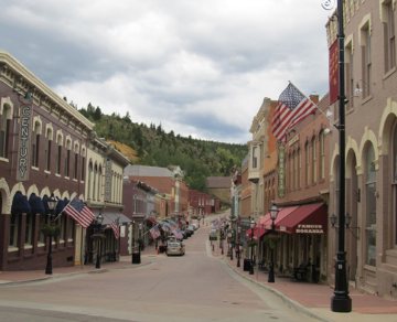
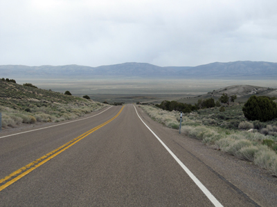 Road in America.” At the same time, AAA representatives warned travelers to avoid this empty 287-mile stretch unless they were “confident of their survival skills.” Much has changed in the last 30 years. The scenery is still wide open, there’s not a lot of traffic, but it’s far from lacking in amenities. This scenic corridor retraces the route of the Pony Express and Overland Stagecoach trails, connects you to plenty of recreational opportunities, and passes through five full-service communities. Eureka is one such stop along the route, and is one of the best-preserved 19th century mining towns in the state.
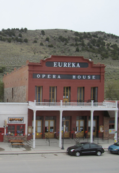
 as determined to find the source. For months, the Georgia native followed North Clear Creek upstream from the present-day city of Golden, and on May 6, 1859, made the first lode discovery in the Rockies! Gregory sold his two claims for $21,000 a few months later and left the area, but his name carries on. “Gregory Gulch” is located between the towns of Central City and Black Hawk. The Gregory Mining District encompasses these towns plus several other mining camps, and as a whole, this area is referred to as "The Richest Square Mile On Earth.” Central City takes it name from being “central” to all the mining activity.
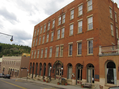 One of the most notable buildings in downtown is the 150-room Teller House Hotel. Located on the corner of Eureka and Pine Streets, it was built in 1872 at a cost of $87,000, plus another $20,000 to furnish. From its non-descript exterior, you’d never believe that the Teller House was once considered to be the most elegant hotel between Chicago and San Francisco. Financed largely by Henry Teller, who became the first senator from Colorado and later, Secretary of the Interior, it’s no longer used as a hotel but is the center for opera-related activities (Central City Opera House is next door).
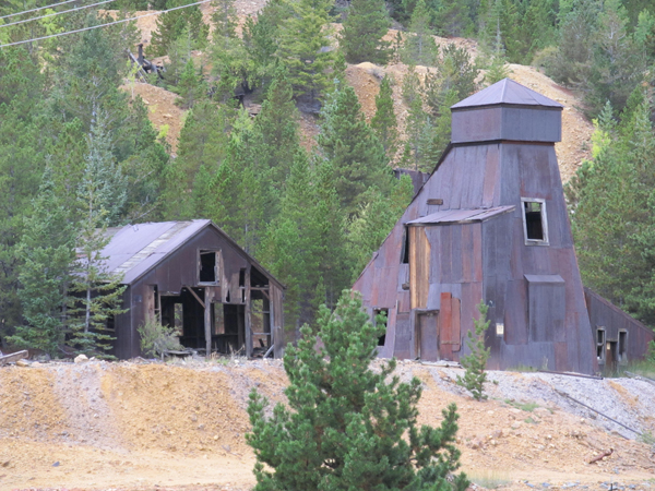 Known for their excellent stonework, the rock retaining walls visible in various places along the route were built by a very large population of Cornish miners. The walls were part of the former Gilpin Tramway, a 26-mile narrow gauge railroad that once looped around the gulches and through the surrounding communities. Sidings went to many of the major mines. Most of the retaining walls don’t use mortar, and were instead constructed using a dry-stack method. After more than a century, most of the rockwork is still holding up— no maintenance required.
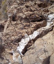 Some say that "gold is where you find it" and while that may be true, once you arrive at a known gold-bearing location, how do you decide where to dig first? Successful prospectors follow different methods, so there is no single "right" way, but no matter if you are sluicing, dry washing, or metal detecting, if you first consider the "lay of the land" you can better pinpoint a place to start.
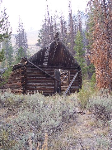 Man-Made Factors to Consider Before Digging for Gold:
|
Nugget of News Blog |