


Saturday, March 26 2022
Gold is gold, so there isn’t necessarily a better type of gold, however, mining for lode gold has many more challenges than mining for placer gold. The formation of gold generally starts as a vein in rock. This is referred to as “lode gold” and is formed when molten rock in the earth’s crust heats groundwater under great pressure. In fractured bedrock with appropriate rock chemistry, super-heated water (hydrothermal) at approximately 400-700 degrees Fahrenheit dissolves certain elements a Placer gold is the gold that most prospectors are more familiar with. Placer gold isn’t really any different than lode gold. It is simply a concentration of gold that is created over time as it erodes from hard rock veins. When exposed at the surface, a mineralized deposit will break down and erode due to reactions with oxygen, water and wind, coupled with temperature fluctuations. Since gold is very dense, it will move downhill much slower than the surrounding sediment. It tends to become concentrated on or near the surface of the lode, forming a “residual placer” close to the original bedrock exposure. Gold found downhill from the immediate outcrop above the nearest watercourse is called an “eluvial placer.” Once it reaches the nearest waterway and is transported by flowing water, the gold now forms an “alluvial placer.” The origin of the dust, flakes and nuggets found by panning and sluicing is usually from a vein up on a nearby mountain. An ore body is a mineral deposit that can be mined, processed and sold at a profit. All ore bodies are deposits. Few deposits are actual ore bodies. Valuable gold deposits in placers are referred to as “pay streaks” instead of ore bodies. Over time, eluvial and alluvial placers can become covered with sediment. When buried long enough and deep enough, these deposits will turn into “fossil placers.” Sometimes the fossil placers are re-cemented into sandstone or conglomerate rock and then must be mined using hard rock techniques. Hard rock ores have mostly fine to micro-fine gold in solid rock; placers contain fine to coarse gold particles in a softer bulk material or matrix. That makes placers much easier to mine and process. Moving soft soil or river gravel is obviously much easier than breaking rock. For small scale miners, though, a rock crusher can pulverize 2 or 3 inch sized rocks into powder in no time! But for the average prospector, panning and sluicing will be more fun and more profitable, and as time goes on, you may wish to upgrade your mining efforts with a highbanker or power sluice, dredge or trommel. Good luck! Saturday, November 27 2021
If you’re ready to head to a sunnier climate this winter to do some desert prospecting, understanding the weather a Sunday, July 14 2019
Alluvial gold refers to tiny gold flakes that come to be through water erosion and movement. In geology, alluvium The alluvial environment is a very complex one, with many natural forces competing with each other. The forces that lay down gold are a summation of many flood water events of varying intensity that cause the reworking of sands and gravels. Between major flood events, water naturally flows along the already created path and typically the gold present in the gravel or on the surface will not move much. But the larger flooding events can change the drainage routes and even the river’s shape. Some curves can be shut off from the stream and bypassed. Where the water speed decreases, gravels will drop out of suspension, creating alluvial pay streaks that are typically located along and near the riverbed. To identify where a pay streak might be located, take the flow of the waterway into consideration. The most productive streaks are formed as a result of major floods that are significant in terms of both water flow and intensity of erosion. Greater amounts of gold are present here as compared to regular gravels. Pay streaks tend to possess a comet-like form. At the “head” or “heart” is found the richest concentration of gold. At this location, the gravel is coarser and the sandy and silty fraction is much less. This little bit of silt is present only for a few centimeters on the surface, laid down in the last phases of the flood as the silt is dropped. The gold in these gravels is typically small flat flakes, with maybe a small picker or two. As gold prospectors, our objective is to learn to read a stream and recognize the pay streaks it contains. Think about where you are going to dig before you start and then repeatedly test the gravel you are processing. It is important to consider the presence, form, and depth of the bedrock on which the water and all the alluvial gravel deposits are sitting. In many cases, the gold will naturally concentrate in the lowest part of the riverbed, making a gold-rich path. During high water events, much of the gold is picked up and put back into motion, which leads to forming new pay streaks. Some will be laid back down along the low line of the stream, but may also end up a little farther downstream. The gravels in contact with the bedrock or false bedrock base are often the richest. The same facts apply to the alluvial pay streaks that are formed on gravel bars— the lowest level of the gold-bearing gravel is normally the richest. The alluvial environment changes over time. Alluvial pay streaks generated 100 years ago could become buried, then subsequently be eroded and exposed again. The erosion might be in part or in total, generating a new series of paystreaks further downstream. Pay particular attention to large boulders and trees. Obstacles like these may partially block the water flow and provide an opportunity for increased gold concentrations, especially behind the obstructions. If there are fissures, holes or natural traps in the stream, be sure to sample these areas, too. Although high water events are sporadic, when you do find a paystreak caused by one, it can be a very productive spot. Stick with it and keep in mind most are small and narrow and best worked by hand with a sluice and gold pans. Nugget of News Blog Monday, July 30 2018
Places where gold naturally concentrates in an environment of streams and drainages are k When deciding where to start sampling, it’s helpful if you think of a river or stream as a sluice box. Waterways obviously don’t have aluminum riffles and matting, however, they do have natural gold traps that do the same thing that a sluice will do— allow gold to settle out of gravels and be caught while the bulk of the sands continue downstream. Heavy material such as gold doesn’t get spread along evenly, it is most likely caught in certain areas. The downstream parts of inside bends in a stream are favorable places to look for pay streaks. Just how good depends on how sharp the bend in the stream actually is. Usually the sharper the bend, the better the pay streak. If a tributary is known to have coarse gold, look at the intersection of the tributary and the main channel. Behind an obstruction (large boulder, an island, or an outcrop of bedrock) is another good place to look for a pay streak. Boulders and other obstructions can create turbulence where ordinarily smooth flowing water turns into fast flowing whitewater. It is between the fast white water and the quiet dark water that gold drops out. The coarsest gold tends to be found on the outer parts of the pay streak, and the finer-sized gold is on the inner part of the pay streak. When you are working, if it seems as if the streak is petering out as you go toward the middle of the water flow because you are finding little gold, this region of the pay streak is often where the biggest number of nuggets are most likely to occur. Once you know where paystreaks form, you might wonder if they are more likely found on bedrock or in gravels. They are nearly always found on bedrock or some sort of false bedrock. False bedrock might include caliche, a clay layer, or just a well-packed hard pan. You may just get lucky and hit something great with your first shovel of dirt, but more likely you’ll need to test a few different places. Even very experienced prospectors need to keep testing to find those hotspots and paystreaks. Good luck and keep sampling! |
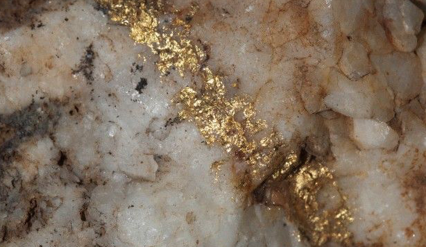 nd molecules from cubic miles of crust and transports them in a circulation loop. When this hydrothermal solution cools or chemically reacts with local rocks, the elements and molecules will come out of the solution and solidify (precipitate), forming ore deposits. The hydrothermal solution will begin precipitating on the sides of the opening and slowly fill the entire crack over time. This is how gold veins can form. These geologic processes take place over millions of years, and can happen many times over many years in the same location. Since the gold is locked up in rock, it is usually pretty hard to get to— usually requiring specialized mining techniques to mine and extract. Lode mining takes a lot more equipment and generally a lot more expense and is usually undertaken by large commercial operations instead of the average prospector.
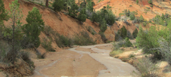 nd topography can add to your success. Before loading up and heading to the Southwest, only to be disappointed by bad weather, first check out the weather patterns for the last 60 days and the predicted weather for the next 30-60 days. Why is that important? Well, it mostly comes down to rainfall— how much and how fast. For example, if there will be a lot of rainfall over an extended time, soils will be loosened and gravity will do its job and cause deeper, and sometimes more concentrated, pay streaks. In general, cool season precipitation (October through April) is the most extensive source of rain in the desert regions. Rainfall is more widespread and of relatively long duration during the cool season. On the other hand, warm season precipitation (May through September) results largely from convective precipitation in the form of short monsoon-type thunderstorms.
 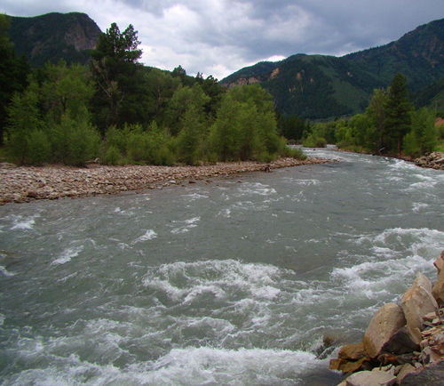 is loose sediment which has been eroded from a primary source, transported and further eroded by water, and redeposited. Since gold is extremely dense, it is easily trapped alongside other dense alluvial particles. The bits of gold found in these deposits of alluvium are called “alluvial gold.”
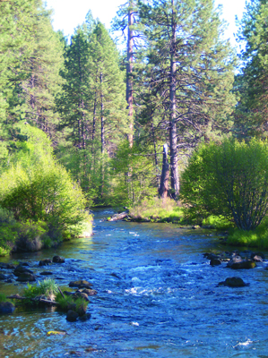 nown as paystreaks. No matter if you are panning, sluicing, dry washing, or metal detecting, in many ways your success at gold prospecting comes down to locating these elusive natural pay streak concentrations. Keep in mind that most gold paystreak formations occur during times of flooding and that many factors affect how gold gets deposited. Perhaps the biggest factor is that gold is dense and is more than 19 times heavier than water. The denser an object, the more easily it will resist the flow of moving water. That means it takes a very strong and fast moving water flow to move along a nugget the size of a pea.
|
Nugget of News Blog |